
Walk Middlesex County Streets Step-by-Step
Start a Middlesex County street directory search with one known address, not a broad street-name guess. The county has 25 municipalities, and a road, postal city, and tax district may not use the same label. Record the municipality before interpreting a result. The useful chain moves from the physical parcel to the assessment record, then to the recorded instrument and only then to dated sources that might identify a household. Each source has a limited purpose. None supplies a complete list of everyone who lives along a street.
- Check the complete address in the official USPS lookup and preserve the returned ZIP and postal city. Then identify the legal municipality and its assessment district.
- Run the location in the county-linked tax assessment search. Save the situs address, block, lot, qualifier, owner name, and any displayed mailing address without treating the mailing field as a residence finding.
- Use the county GIS resources to place the parcel on the street and note parcel geometry, street frontage, and adjacent block and lot numbers.
- Search the County Clerk’s records with the town plus block and lot, legal description, or party fields. A deed can connect the parcel to a prior transfer.
- For a dated household clue, check reverse or criss-cross directory material at Rutgers, then compare the edition with census or newspaper evidence.
Use the NJ Voter Information Portal only to check a person’s own public registration status under its rules. It is not a street-browse tool or a household roster. Municipal building, planning, and code offices can also have address-keyed files, but no single countywide permit or code index was verified.
Middlesex County Address Search Fields
The county-linked assessment search is the first address tool for a Middlesex County street directory. Its gateway requires a database, county, municipal district, search format, output format, and page-size choice before the criteria area is useful. Districts 1201 through 1225 correspond to the county’s 25 municipalities. Choose the district carefully because a street result without that context can be misleading.
| Visible field | Control | When used | Street-search value |
|---|---|---|---|
| Select Database | Dropdown | Gateway step 1 | Chooses the assessment database |
| Select County | Dropdown | Gateway step 2 | Choose Middlesex |
| Select District | Dropdown | Gateway step 3 | Sets the municipal tax district |
| Select Search Format | Dropdown | Gateway step 4 | Determines the criteria mode |
| Select Output Format | Dropdown | Gateway step 5 | Determines the result layout |
| Location | Text | Criteria-dependent | Address, street, or location search |
| Owner Name | Text | Criteria-dependent | Preserve the spelling returned by a parcel result |
| Block, Lot, Qualifier | Text | Criteria-dependent | Links the parcel to GIS and deed research |
Assessment output is tax and sales information, not a deed image or proof that someone occupies the property. The portal warns that recent SR1A sales may not have completed usability investigation, that assessments are not evidence of value, and that not all sales are usable. Capture the selected district, query, output, and access date with each result. Municipal assessors and tax collectors handle corrections and local tax questions; the County Tax Board supervises assessment data.
Note: A location result is strongest when its municipality, block, lot, and source date are kept with the address.
Middlesex County Parcel Context
The Middlesex County GIS Division provides county geodata, web applications, static maps, and Open Data links. Use it as a cartographic bridge. Locate the street or parcel, inspect the visible geometry, and carry the parcel identifier to the assessment system or the County Clerk. The research did not confirm every live map layer, pop-up field, or tool label, so a result should be checked in the current application rather than assumed from an older screen.
- Parcel
- A defined piece of land recorded and assessed as a unit. Its block and lot can remain useful when a printed street address changes.
- Situs address
- The physical location of the parcel. It is not the same thing as an owner’s tax mailing address.
- Plat or recorded map
- A filed map that can identify lots, streets, or a subdivision. It is different from a general online map view.
- Criss-cross directory
- A reverse directory arranged by address or street, used as a dated historical lead rather than a current resident list.
Parcel lines, roads, and public layers supply context, not final legal proof. The controlling legal description is in the recorded instrument and the relevant municipal or county record. If an adjacent parcel is relevant, note its block and lot, then make a separate assessment and deed check rather than assuming proximity proves a relationship.
Middlesex County Address Records
A Middlesex County street directory can draw on several address-keyed sources, but their results should remain distinct. The record table keeps ownership, mapping, history, and municipal activity in separate lanes. It also shows why an address search needs a fallback beyond a web form when an older document or local record is missing.
| Address record | Custodian | What it can show | Access route |
|---|---|---|---|
| Tax assessment | Municipal assessor and County Tax Board-linked search | Owner, situs, displayed mailing address, block, lot, class, assessments, exemptions, and sale data | Online search, municipal assessor, Tax Board, or OPRA for maintained records |
| GIS parcel record | County GIS and municipal data partners | Parcel geometry, identifier, map setting, adjacent parcels, and available public layers | Open Data and web-map links; live layers vary |
| Deed and index | Middlesex County Clerk Registry | Parties, recording, legal description, consideration, and prior-deed references | Online coverage varies by record; search room and State Archives for older material |
| Mortgage, lien, release | Middlesex County Clerk Registry | Encumbrance, lender, debtor, discharge, or cancellation | Online notices begin later than deeds; older material is at the office |
| Permit, certificate, zoning file | Municipal office | Address, work type, status, and fields available under law | Municipal custodian or a specific OPRA request; no countywide index located |
| Tax sale or foreclosure material | Municipal tax collector, County Clerk, and Superior Court | Delinquency, lien, docket, and legal notices | Office notice, land-record search, or court route |
| Reverse directory | Rutgers, libraries, and local collections | Dated occupants, occupations, institutions, and nearby entries | Historical collection, not a current roll |
The municipality controls many address records. Ask a municipal office for a date range and a specific address, then request the non-exempt portion that is maintained. Middlesex County guidance says an OPRA request normally receives a response within seven business days, subject to the record and circumstances. OPRA does not require a custodian to create a new list or release protected fields.
Middlesex County Deeds by Street
The Middlesex County Clerk Registry is the route from a parcel to recorded transfers. BrowserView can search by town, document type, date, party name, lot and block, parcel ID, map number, instrument number, book and page, and legal-description fields. For an address-led search, take the block, lot, and legal description from assessment or GIS first. Then test party, legal-description, or lot-and-block searches with the legal municipality.
The public notice states deeds from 1929 forward, mortgages from 1950 forward, and other documents from 1958 forward. A 2022 county announcement says deeds were digitized back to 1923. That difference matters. County deeds have been on file from 1683, yet older books and indexes can require the public search room, State Archives microfilm, Rutgers, FamilySearch references, or a written request. Search spelling variations because the Clerk warns that indexed names can vary.
The Official Records public search shows field groups that make a town, parcel, and party search more precise than a bare street name.
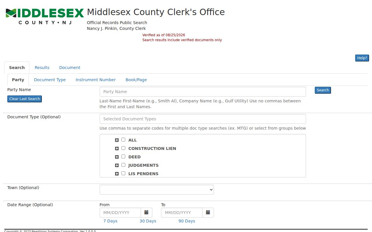
A recorded image may supply grantor and grantee names, consideration, recording date, book and page or instrument number, legal description, municipality, block and lot, acknowledgments, and attachments. Statuses other than V or B are not verified in the browser instructions, while R and C mark replaced and correction records. Do not republish sensitive information that appears in an image.
Middlesex County Street Directory Geography
Street searches need both the postal label and the legal municipality. Fords and Iselin addresses may be legally in Woodbridge. Dayton and Kendall Park may be in South Brunswick. Parlin may be in Sayreville, and Monmouth Junction is a postal or community label within South Brunswick. The USPS ZIP Code Lookup confirms delivery information for an address, but it does not confirm that a person or organization is associated with that address.
Practical search tip. Search the postal city and legal municipality separately, then reconcile the result through the complete address, district, block, and lot. A ZIP is a delivery category, while the tax district and legal description belong to the property record. Preserve Road and Rd, Route and Rt, directional forms, units, old street names, and the original string as separate variants when a search fails.
Historic material needs the same care. The 1855 New Brunswick directory and county house-history material describe an Albany Street location with differing numbers and a Water Street rear address. Search alternate numbers, a cross street, landmarks, and adjoining owners rather than silently forcing an older source into a newer address form.
Middlesex County Street Directory History
For past occupants, use a Middlesex County street directory as a dated historical source. Rutgers reports especially complete New Brunswick city-directory coverage from 1855 onward, but the volumes are in closed stacks and exact annual availability should be confirmed with the New Jersey Room reference desk. County directories can be on open shelves, and nearby towns can appear under a city title. A reverse section may place an address first, after which the alphabetical entry can be compared across editions.
A directory can include a name, household relation, occupation, street number, business, and address notation, but its abbreviations are volume-specific. Read the volume’s own key before expanding marks such as h, r, wid, bds, rear, opp, or cor. The historical collections themselves are described in the Middlesex County city directories; here, use a dated edition as one part of the address chain.
Note: A directory entry is a periodic snapshot and should be checked against another dated source before drawing an address conclusion.
Middlesex County Street Record Requests
Municipal construction, planning, and code offices keep the county’s address-specific permits and cases. There is no verified countywide public portal covering every municipality. For a targeted request, provide the municipality, complete address, date range, and the record type sought. Ask for the permit number, work description, status, application, inspection history, certificate of occupancy, or other maintained non-exempt record rather than asking a custodian to assemble a new street list.
When a web search fails, the fallback chain is the municipal custodian, the County Tax Board for assessment routing, the County Clerk for land records, and OPRA for identifiable county or municipal records. Keep the acknowledgment, response, fee estimate, production, redactions, and stated legal basis for any denial. A no-record result describes a particular query, not necessarily the absence of all records.
Middlesex County Address-Record Limits
A common mistake. An owner name, an assessment mailing address, a voter record, and a directory entry do not all prove present occupancy. The assessment system identifies tax information. A mailing address can be an attorney, business, bank, relative, or other tax destination. A directory is dated. Public voter information is subject to state rules and protected-address limits. Use each record for what it actually establishes.
A street search cannot produce a complete private household list, utility customer list, delivery list, motor-vehicle list, or protected-address list. New Jersey’s Address Confidentiality Program, Daniel’s Law protections, and voter-address rules restrict some information. The NJ Voter Information Portal is a personal status check, while the Middlesex Board of Elections and the proper custodian handle other lawful public-record questions.
Lawful use. Middlesex County address records support personal, family-history, property-history, and civic research. Do not use public records to stalk, harass, intimidate, or harm anyone, and do not infer private household details from a parcel result.
Middlesex County Street Directory Checks
Keep a small research log for every Middlesex County address: exact original address, normalized form, municipality, postal city, ZIP, tax district, block, lot, qualifier, legal-description reference, source URL, access date, and result type. Mark each result as a current portal status, a dated historical record, an index lead, a no-record result for a query, or protected and unavailable. That distinction prevents an old directory or incomplete online index from being mistaken for a current answer.
The County Clerk’s Property Alert is another ownership-record safeguard. The free service can notify a subscriber after a matching document is recorded for a legal description, municipality, block and lot, or party name. It is a notice after indexing, not prevention. Review the actual recorded document and use official county contacts if an unfamiliar filing appears.